
Want life-saving information? You’ll need to ‘opt-in’…

To be sure evacuation notices come to you, be sure to ‘opt-in’ to Citizen Alert.
When the McKinney fire broke out near the California border, I worried. As the crow flies, the flames were only 16 or so miles away from my home in the Applegate. Was it something I needed to worry about now? In two days? Should I worry at all? I checked Facebook. People in Talent posted about a red glow on the horizon—sounded serious! But Jefferson Public Radio didn’t seem too concerned: an Irish reel played on the FM station. And on the AM station: a discussion of Japanese kimonos.
That’s when I realized that despite there being a dozen websites, listservs, and Facebook pages on smoke and fires, I was still uncertain how I’d know if I ever needed to evacuate.
I called Josephine County Emergency Manager, Emily Ring, to ask about local emergency alert protocols. I’m glad I did. It turns out, getting notifications often requires you to be proactive about it; alerts don’t necessarily come to you—as in the case with tsunamis on the coast, or tornadoes in the Midwest.
“In the case of a tornado or tsunami, sirens send a clear message of what to do: get to high ground, or go in the basement. With a fire, sirens might be able to tell you there are flames nearby, but not what to do, or which direction to go.”
Wildfire alerts, she explained, require more specific information–which makes the process a bit more fraught: Issuing too general an alert creates unnecessary panic, causing traffic and chaos in unaffected places. But issuing too narrow of an alert creates problems, too— resulting in too few people getting an evacuation notice.
Emily said community vigilance and neighborhood communication networks are an important part of staying informed, but that every citizen should also know how to access three key county-wide resources: Citizen Alert, Pulse Point and the Jackson and Josephine Country Fire maps.
Here is more information on each resource below.
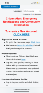
Evacuation alerts will come to you if you have a landline, but if you have a cell phone, you’ll need to opt-in to receive them.* You do this by going to the Citizen Alert website and filling out an online registration form, complete with a password. This method is hosted by a platform called Everbridge.
While Citizen Alert provides more delivery and sending options and more targeted information, you can also opt in to a program called Nixle. Nixle allows you to opt in for specific alerts by texting certain codes, like JACKSONEVACS, to 888-777.
Emily recommends opting in for both Citizen Alert and Nixle. If you want to make a deep dive into the differences between the systems, visit “Know Your Alerts” on the Rogue Valley Emergency Management page. (insert link)
*An exception to this is the Integrated Public Alert & Warning System (IPAWS) which allows FEMA to overtake cell phone towers and radio/TV networks to issue Amber Alerts, or widespread alerts for natural disasters.
2. PulsePoint
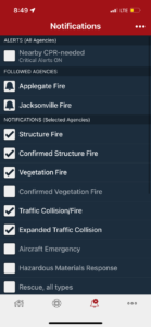
This phone app was originally designed to alert nearby citizens of cardiac incidents– in the event that someone who could perform CPR was nearby. Now, it has a much broader use, providing real-time updates on all types of emergencies: structure and vegetation fires, traffic collisions, aircraft emergencies, rescues, flooding and hazardous materials issues. If you don’t want your phone pinging all the time, you can choose which emergency types you want to be notified of, and in which geographical areas.
While PulsePoint’s up-to-the-minute information is useful, it does not update you on emergencies as they unfold, tell you how they resolved, or what actions to take.
3. Jackson and Josephine County Fire Information Map and Evacuation Zones (links below)
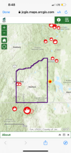
When official evacuations are occurring, these county maps provide a good interactive and visual way to see the areas impacted. The map feature clickable widgets that provide information on acres burned, containment and when the incident started. The maps are updated continuously and can alert you to evacuation levels 1,2 and 3. You can also enter your home address for more site-specific information.
For Jackson County click here.
For Josephine County click here.
Having to opt in to receive life-saving information does not seem ideal. Some people struggle with technology, or have limited access. However, since that is how the system currently works, it’s a good idea to put some time into learning about the systems—even if that means asking for assistance, Emily says that anyone struggling to register (or navigate the apps or websites) can call the Jackson County Emergency Management office at 541-774-6790, or the Josephine County Emergency Management office at 541-474-5300.
If due to a disability, you need special help receiving notices or coordinating evacuation, residents of both counties can register here at the Rogue Valley Council of Governments.